Ride Statistics
Total Distance:
13.39km | 8.32mi
Starting Altitude:
244m | 801ft
Finishing Altitude:
1,485m | 4,872ft
Average Gradient: 9.3%
Elevation Gain:
1,271m | 4,170ft
Surface Type:
Smooth Bitumen / Asphalt
Difficulty: 166

Mont du Chat Hill Climb

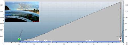
Very nice peacefull climb wooded all the way up ( mixed woodland to start then just pines ) . First few k's are around 8% then about a km of 12% then a steady old 10% for the rest of it ! Superb views of the lake , Aix le Bain & Chambery airport from the summit :-)
Distance: 13.39km | 8.32mi
Attempts: 1
Elevation Profile

Directions
Signed as 'Relais du chat' from Bourget .
Start Point: Bourget du Lac village centre ., stationary
End point: Buildings & Telecom mast at summit.
Map & Route to Mont du Chat
Summary

Fastest Hill Climbs
View All Attempts
| Enter My Attempt
1.
1hr 28mins 37secs
- 23 Apr 2010:
Nick .
View All Attempts »
Comments
Currently No Comments