Ride Statistics
Total Distance:
15.00km | 9.32mi
Starting Altitude:
334m | 1,096ft
Finishing Altitude:
1,433m | 4,701ft
Average Gradient: 7.3%
Elevation Gain:
1,100m | 3,609ft
Surface Type:
Smooth Bitumen / Asphalt
Difficulty: 125

Mont Serein ski station. Hill Climb

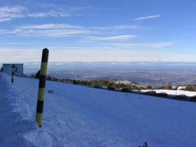
This is the first 15km's of Mont Ventoux from Malaucene ...it's as far as you can get in winter due to snow.
Distance: 15.00km | 9.32mi
Attempts: 2
Directions
The climb starts as you take the turn in the middle of Malaucene signed for Mont Ventoux on the D974.
Start Point: T intersection in centre of Malaucene., stationary
End point: Roundabout opposite ski chalet ( the only roundabout )
Map & Route to Mont Serein ski station.
Summary

Fastest Hill Climbs
View All Attempts
| Enter My Attempt
1.
1hr 17mins 6secs
- 14 Feb 2012:
Nick .
View All Attempts »
Comments
Currently No Comments