Ride Statistics
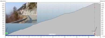
Total Distance:
15.01km | 9.32mi
Starting Altitude:
280m | 919ft
Finishing Altitude:
1,134m | 3,720ft
Average Gradient: 5.7%
Elevation Gain:
856m | 2,808ft
Surface Type:
Smooth Bitumen / Asphalt
Difficulty: 86

Col du Granier Hill Climb

The 1933m Mont Granier towers impressivley over this col wich passes through the very distinctive horseshoe profile that can be seen from the valleys below . A nice sensible gradient with some long false flat sections for recovery or acceleration !
Distance: 15.01km | 9.32mi
Attempts: 1
Elevation Profile

Directions
From the motorway follow signs through Chambery for the 'Massif de Chartreuse' until you get to the roundabout at Rue Costa de Beuregard. The climb starts there on the Rue Jean Jaques Rousseau. From there follow D912 for Granier / Massif de Chartreuse.
Start Point: Roundabout at the foot of the Rue jean Jaques Rouseau., rolling
End point: Cafe at summit.
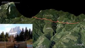
Map & Route to Col du Granier
Summary

Fastest Hill Climbs
View All Attempts
| Enter My Attempt
1.
57mins 24secs
- 25 Apr 2010:
Nick .
View All Attempts »
Comments
Currently No Comments