Ride Statistics
Total Distance:
20.50km | 12.74mi
Starting Altitude:
1,400m | 4,593ft
Finishing Altitude:
2,744m | 9,003ft
Average Gradient: 6.5%
Elevation Gain:
1,344m | 4,409ft
Surface Type:
Smooth Bitumen / Asphalt
Difficulty: 135

Col de Agnell Hill Climb

Distance: 20.50km | 12.74mi
Attempts: 3
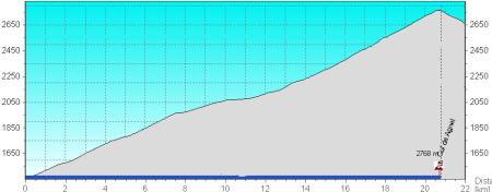
Elevation Profile

Directions
2.5km's after Chateau Queyras you come to the Village of Ville Vieille , hang a right at the roundabout & start the watch as you pass over the Guil river bridge. 7% for the first 8k's , 8 % for the last 8k's & a 5k section of 3.5 % in the middle :-)
Start Point: River bridge at roundabout in Ville Vielle., rolling
End point: French / Italy sign at summit.
Map & Route to Col de Agnell
Summary

Fastest Hill Climbs
View All Attempts
| Enter My Attempt
1.
1hr 49mins 48secs
- 31 Jul 2007:
Nick .
2.
1hr 57mins 14secs
- 29 Aug 2011:
Patrick Kenny
View All Attempts »
Comments
Currently No Comments