Ride Statistics
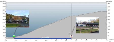
Total Distance:
2.87km | 1.78mi
Starting Altitude:
41m | 135ft
Finishing Altitude:
182m | 597ft
Average Gradient: 4.9%
Elevation Gain:
135m | 443ft
Surface Type:
Smooth Bitumen / Asphalt
Difficulty: 29

Box Hill , Surrey. Hill Climb

http://www.infobritain.co.uk/Box_Hill.htm
Distance: 2.87km | 1.78mi
Attempts: 4
Elevation Profile

Directions
Start Point: Mickleham 200AD sign at Burford Bridge., rolling
End point: National Trust cafe/shop at summit.
Map & Route to Box Hill , Surrey.
Summary

Fastest Hill Climbs
View All Attempts
| Enter My Attempt
1.
8mins 10secs
- 26 Jun 2011:
David Mulligan
2.
8mins 55secs
- 27 Oct 2011:
Nick .
View All Attempts »
Comments
Currently No Comments