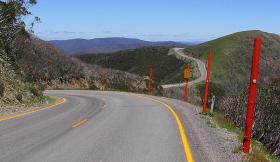
Ride Statistics
Total Distance:
30.35km | 18.86mi
Starting Altitude:
510m | 1,673ft
Finishing Altitude:
1,821m | 5,974ft
Average Gradient: 4.7%
Elevation Gain:
1,415m | 4,642ft
Surface Type:
Paved
Difficulty: 115

Mt Hotham Hill Climb

Distance: 30.35km | 18.86mi
Attempts: 245
Elevation Profile

Directions
School Bridge is on the corner of Mt Feathertop Road and the Great Alpine Road. The highest point on the road is about 1 kilometre from finish (look for 80 speed sign). 1821 metres is NOT the finishing altitude - it's the highest point on the road.
Start Point: School Bridge (Harrietville), stationary
End point: Hull Skier Bridge (you can't miss it ! )
Map & Route to Mt Hotham
Summary

10 Fastest Hill Climbs
View All Attempts
| Enter My Attempt
1.
1hr 12mins 7secs
- 06 Dec 2009:
Jason B Spencer
2.
1hr 13mins 5secs
- 15 Dec 2008:
Ben Dyball
3.
1hr 14mins 35secs
- 07 Dec 2008:
Brodie talbot
4.
1hr 18mins 42secs
- 02 Dec 2007:
Peter Riseley
5.
1hr 20mins 32secs
- 03 Dec 2008:
Stuart Payne
6.
1hr 20mins 35secs
- 01 Oct 2006:
Jono Lovelock
7.
1hr 22mins 8secs
- 06 Dec 2008:
Marty McFly
8.
1hr 22mins 47secs
- 27 Oct 2007:
Justin Wornes
9.
1hr 23mins 3secs
- 05 Dec 2010:
Trevor Spencer
10.
1hr 24mins 45secs
- 05 Feb 2012:
Alex Koller-Perger
View All Attempts »
Comments
Currently No Comments